Tuesday, September 24, 2019

A Voyage to Remember

This adventure has previously been posted on my boating blog, but it also is appropriate as travel commentary. 

When I was on active duty in the US Navy, 1966-68, I initially attended navigation school in San Diego.  The subject was interesting enough to me that I continued to study available nautical references onboard the two ships on which I served.  Spending many hours per day on the ship’s bridge deck for months at a time (crossing the Pacific twice, navigating the Mekong Delta, patrolling the Vietnam coast and Gulf of Tonkin, and cruising to Japan for maintenance) provided plenty of time for such review.

Later, in 1976 while visiting Hawaii, I picked up a reference on Polynesian navigation techniques (We, the Navigators) to help understand how the early voyagers were able to find their way in the ocean’s vastness.  In late 1980, our family was living in Panama.  My dental assistant and her husband were buying a used 44’ trawler (single diesel engine) in Florida which they intended to bring to Panama to live and cruise on.  They asked me if I would act as navigator for the trip from Miami to Colon, Panama.

They offered to pay for my flight to Miami, which I declined.  If I were to do this, I wanted it to be from a sense of friendship rather than any monetary obligation.  I provided a list of the different nautical charts, references, and instruments which would be necessary for such a trip.  My assistant’s husband, Charles, was a retired US Navy diver who now worked for the Panama Canal Company.  He was to fly to Miami and spend one week examining and preparing the boat, including obtaining the necessary navigation supplies, before we left port.  He was one very tough individual and totally fearless.  He recruited a third crew member, Bill, who I hadn’t previously met but who seemed like a solid character.  It would be just the three of us on a quick voyage back to Panama.

I had talked to one of my patients, then employed as a canal pilot, who had previously been a Caribbean charter captain.  He gave me a route recommendation, which appeared reasonable, and loaned me his sextant.  I flew to Miami on a Saturday in early December, took a cab to the yacht basin, and was prepared to leave harbor the following morning.  Upon arrival, I asked about the navigational charts and references and was stunned to discover that none of the publications I requested had been purchased because it was now December 6, and the contained data was only good through the end of the year. 

They were deemed too expensive to obtain for such a short period of use, but without the sight reduction tables, the sextant was useless.  Also, only one chart had been obtained.  It was an overall chart showing Miami toward the top edge and Panama at the bottom edge.  With such a large area to cover, the chart lacked any detail of depths and features of the various coastlines.  Additionally, the trawler had only been maneuvered on various headings once to check the accuracy and deviation of the compass.  The boat was equipped with a radar set, but the range was only a few miles.  LORAN coverage of the southern Caribbean was lacking at that time, and GPS had not yet been invented.  This was shaping up to be quite a challenge, and I was glad I had some knowledge of navigation without dependency on instruments.

Twelve-foot swells off the stern of the 44' trawler in the Gulf Stream.


Checking on supplies, the trawler was almost empty with very little on board for ballast, just some groceries, a few tools, and our suitcases.  Our only refrigeration was a single large ice chest.  On Sunday morning, we set out on our adventure.  The first leg was to follow the coast of Florida southwest to Key West, then head straight south to the coast of Cuba.  The hurricane season officially ends November 30; we were now in December but encountering strong winds.  As we headed south from Key West we were headed into night, crossing the Gulf Stream with a strong current from the west opposing strong wind from the southeast which made for large, steep waves against our under-ballasted hull.  Forty-four feet may sound like a large vessel, but, on the open ocean, it is a tiny presence.  The strong wind created a surface haze of spray allowing very limited visibility.

Instead of an enclosed bunk, I had a bed to (try to) sleep in at night.  I tried to hold onto the bed, wrapping my arms and legs around the mattress while resting, but was completely thrown out of the bed once by the lurching hull.  Once I heard a scream from Bill, “We are going over!” as the boat slid sideways down the face of a wave with the rudder seemingly useless.  Fortunately, before we were rolled in a trough by the next wave, the rudder finally caught hold and the bow came around sufficiently to face it.  When it was my time to go on watch, I filled a paper cup with water and held it in my hand.  If I were to fall asleep, I would drop the cup, and it would be my alarm.  It worked.  Everyone needed what rest they could get; there was no asking someone else to take part of your watch.

We were glad to see the morning but were now presented with a new problem.  Our large chart showed no detail of the Cuban coast.  As we continued south, we wanted to approach the coast as a navigational reference but not get so close that Cuban gunboats would escort us into port.  The solution was Polynesian navigation using cloud formations.  Distinctive cloud formations are found over islands.  Although we never actually saw Cuba, we followed its cloud formations west along the coast while staying offshore.

As evening set in, we were ready to jump off from the west end of Cuba toward Mexico.  It is an easy dead reckoning exercise (hard to miss Mexico) but it also meant re-crossing the Gulf Stream as it flows north.  We subtracted a few degrees from our compass course to allow for the current and set off into the night.  The next morning, we sighted Isla Mujeres and pulled into port for refueling.  That afternoon we headed back out to sea with Cozumel to starboard and the Swan islands as our next intended waypoint.

Heading southeast, we encountered rising wind and waves from the northeast.  As the hull angled into the face of each oncoming wave, it was obvious that the "thump, thump, thump" sound of the big single diesel slowed significantly.  The engine was losing power.  Upon inspection it was discovered that sludge, stirred up from the diesel fuel we just received, was clogging the fuel filter.  The engine was being starved for fuel.  To clean the fuel filter, we needed to stop the engine.  Then it was discovered that the alternator, used to charge the batteries, was not working.  The batteries were very low on electrical charge.  If we stopped the engine, it was doubtful that the batteries held enough current to restart it.  It was time to change course and our plan.

We turned to run with the wind toward the southwest for a smoother ride and slowed boat speed slightly to match the speed of the waves and reduce engine load.  We shut off almost all electrical equipment to save the batteries, and Charles went down in the belly of the boat, holding electrical wires by hand on the batteries until the battery acid started to bubble, in an attempt to recharge the batteries.  Through the night we steered manually, using a flashlight to read the compass, and no running lights.  When it was my turn to lie in bed, I wondered what the future would hold if that engine stopped; what bit of shoreline or reef would the drifting hull crunch coral on?  Fortunately, the engine kept "thumping".

Isla Mujeres, Mexico, 1980.  I include the date because several years later a disease hit the island and killed all the palm trees there.  Hopefully by now, the palm trees are healthy and growing again.


The next morning, we could see some of the Bay Islands near the coast of Honduras in the distance off our port side.  The wind and waves were still strong.  Charles thought that the downwind island was Roatan and suggested we aim for it.  I pointed out that if he was wrong, we would be unable to work our way back to any of the islands further upwind.  So we angled our course to port and headed for the nearest island.  It turned out to be Roatan.  The old wooden wharf was on the lee side of the island, allowing us to get out of the wind and motor quietly up to the dock (where I was to receive quite a surprise).

I was standing on the bow, dock line in hand, peering intently at the dock’s shabby state with substantial holes punched in its gray, wooden-planked surface.  I wanted to make sure that when I leaped to the dock to tie up, I didn’t put a foot through one of those holes.  Suddenly, a young black man came out on the dock, and his first words, in clear English were, “Hey, did you hear that John Lennon was shot and killed?”  Here I thought I was in some remote place far from the beaten path, and I was getting the latest news in my own language!  Mainland Honduras inhabitants speak Spanish, but on the Islands, they speak English due to previous British influence.  In Roatan we were able to get an alternator from a wrecked yacht which Charles and Bill then installed.  The fuel filter was also cleaned, and we had a good meal and rest at anchor before leaving the next morning.

Dixon Cove, Roatan, 1980.  Local transport in a dugout canoe.  Seldom seen there today; we did see some of these hollowed-out log watercraft in Panama, but they were generally much larger (bigger trees?).

We are looking at the biggest nightclub in the town of Roatan, 1980.  Today, the area is more presentable but still somewhat shabby.


We cruised east along the Honduran coast taking turns on watch.  The following morning when I came up on deck, I was immediately concerned.  I looked down at the ocean and saw churned brown water.  I yelled to Charles that we were in too shallow of water and were in danger of running aground.  He replied that the radar range he had taken indicated that we were a sufficient distance from the beach.  I pointed out that the radar was not being reflected from the gently sloping sand beach, but from a line of tall palm trees several hundred yards behind the beach.  We immediately turned out to sea until we were in clear blue water.  Later that day we passed Cabo Gracias a Dios which held a lesson for us.  The Cabo is the outlet of a major river marking the border between Honduras and Nicaragua.  A submerged tongue of silt, an invisible delta, stretches miles out to sea at this location.  You can be miles from the coast and still run aground in very shallow water.  Several shipwrecks stood as evidence.

From here we headed south and slightly east out on the open seas, away from the Nicaraguan coast, with the next intended waypoint being the island of San Andres.  The weather was now good, and we were able to troll and catch fish for dinner.  Our ice chest no longer had any ice or fresh food, so the fish was appreciated.  We were again dead reckoning [basically following a compass course allowing for expected currents and other influences] for navigation.  We never actually saw San Andres but were again aided by Polynesian navigation using wave patterns.

Ocean waves obey the same principles of physics as other types of waves.  When ocean waves or swells reach an island, the lines of wave crests are slowed causing a diffraction or bent angle toward the shallow water; on the lee side of a small island, you will see a cross-hatched pattern of waves from being diffracted around both ends of the island.  This phenomenon extends for miles downstream from the land.  Our intended path was planned so that if we didn’t actually sight the island we would pass on its lee side, and that is what happened.  Watching the wave pattern closely, you could see the oncoming waves transition to a cross-hatched pattern as we passed on the lee side of San Andres and then resume their undisturbed linear pattern as we came back into the clear.  Observing such a pattern, we knew where we were.

For the ancient navigators on the Pacific Ocean, you can understand how important it was for them to understand natural phenomena to expand the “target size” of the islands they were seeking.  From an ocean liner, at some height above the water, the horizon is distant, but from the deck of a small boat the horizon may be only 2-3 miles away.  When I was in the US Navy and we were approaching Midway Island, we had the advantage of a huge radar array atop a tall mast and still only detected the low-lying island from about 15 miles away.  The Polynesian navigators understood clouds and waves and had memorized the passing star groupings in an ever-revolving sky with its seasonal variations so that the stars provided a map to follow.  Additionally, they knew the seasonal direction of swells (separate from waves), the patterns of bird flights, as well as other more subtle influences, and had memorized the legends of previous voyages.  Think of it as their equivalent of an advanced college degree.  I had only learned a few of their “beginner” topics.
 
On a calm evening at sea, we continued southeast toward the coast of Panama.  I miss-judged slightly in estimating the coastal currents; when we sighted the Panama coast the next day, we were 10-20 miles east of the Colon harbor entrance.  But it was a familiar coast, where my wife and I had spent numerous snorkeling and sailing trips, and only a short cruise to correct our position.  During the trip, each of us had been emotionally self-contained.  We simply focused on the mechanics of getting through each day.  No long conversations; no sharing of concerns.  I still didn't know Bill's background, and he didn't know mine.  However, at the entrance to the harbor Bill turned to me and said, “If I were to meet someone who wanted to do the same trip with me as crew, I would charge them at least $2000.”  [Remember, these were 1980 dollars] I turned to him and said, “Funny, I was thinking the same thing, and I came up with the same price.”

Back in Colon harbor.  Our children were quite young at the time.  My daughter told me, "Daddy, we need to get you home and take the yuckies off your face."


Months later, my wife Dawn and I would cruise with Charles and Jean to the San Blas Islands where we did run aground with their trawler, but that is another story.

Wednesday, August 28, 2019

A visit to Omaha

Dawn and I traveled to Omaha this past weekend for my mother's 101st birthday.  Not exactly a big trip, but I think that it may include a story worth re-telling.  Our world has changed so much since she was born.  In attendance at the birthday party were her 97 y.o. brother and her (almost) 92 y.o. sister.  We encouraged them to tell us stories of their childhood.

When my mother was born, World War One was still raging and the world was also caught in a pandemic influenza outbreak which killed millions of people.  Antibiotics had not yet been developed.  She was raised on a large, 240 acre, farm with a large farmhouse (two stairwells and five bedrooms).  However, their home had neither electricity nor running water.  The stove was heated by burning corncobs retrieved from the hog lot after the hogs had eaten the corn kernals off  (and the poop had been knocked off).  Only the kitchen and parlor were heated.  The farming was done with horses.  During the summer, the men worked the fields until sundown and the children carried their meals out to them.  As children, they remember no discipline problems; too busy with farm chores to get into trouble.  Their grade school was a fairly convenient walk, only 3/4 mile away.  The mailbox was 1/4 mile distant.  On snowy winter days, sometimes her father would hitch up the wagon and horses to take them to school.

Then the great Depression came; times were hard.  The material from flour sacks was used to make clothing.  Christmas brought an apple or orange in your stocking hung by the fireplace.  At that time there were five children; the only holiday present one year was a board with holes in it where the children could compete to toss marbles through the holes.  Toys were what you made up yourself using your imagination.  When a horse died, they skinned it and made a horsehide blanket.

My mother recounts that when she started high school there were 48 children in her class.  When she graduated there were only 24; the other half of her class dropped out to help at home on their farms.  My mother was valedictorian of her high school class (all 24), but there was no thought of further schooling.  She got a job as a domestic: cleaning and caring for children in other people's homes.  She had an attic room to stay in when she worked for a couple in the city of Omaha.  Eventually she got a job as a bookkeeper for Robinson Seed Company.  Interestingly, bookkeeping was a standard course she had been taught in high school.  Subsequently, she met my father who, at age 22, was back home after four years in the US Navy.

Her brother had played on his high school basketball team, although he had not been introduced to the sport until entering high school.  Her younger sister had been a cheerleader for all four years of high school.  Their parents never attended any of their games.  Not sure of the reason why.... were they too busy on the farm?  Her sister married her high school boyfriend; he was killed in a tractor mowing accident shortly afterwards.

All three siblings were affected by WWII.  My mother had two children to care for while my father was called back into the Navy to serve during the war.  Her brother, graduating from high school in 1940, received a deferment to help out on the farm but was called up to serve near the end of the war.  Her sister, after her first husband's death, remarried to an ambitious young GI returning from the war. 

It is great that my mother and her siblings are so mentally sharp.  They look back on what they view as pleasant childhoods.  All their neighbors were enduring the same conditions that they lived with.  Will we be able to enjoy such a gathering next year?

Think of the many changes in the past 100 years!  Not just no TV or internet... no electricity.

Postscript:   My mother died at age 104 1/2.  She always considered herself as a very fortunate girl from a farming background and still felt the presence of her deceased husband and loved him until her death.    


Sunday, July 28, 2019

Washington, DC, -- Azores-- Maine & Mass.

We have a new granddaughter in Washington, DC; it is time to plan a visit there.  And, as long as we are going that far, might as well make a trip out of it.  Dawn has been wanting to visit the Northeast: Cape Cod, Boston, Martha's Vineyard, the Maine coast.  I have been wanting to see more of the Azores islands; Boston is the gateway for flights from the US to Azores.  Thus, we have the outline for our next trip.

Washington is familiar; we visit about twice a year and I previously lived there for two years; that is not new territory.  We have an apartment rented there for a few days.  Then we fly to Boston where we pick up an overnight flight to Ponta Delgada, San Miguel island, Azores.  We have been to Ponta Delgada before; greatly enjoyed it and want to see more of the Azores now.  Thus, we take a connecting flight to Terceira island for a few days; fly onward to Flores island (only 4000 residents) for a several-day stay; then hop back to Ponta Delgada and connect homeward to visit Boston.

Only one airline, SATA, provides inter-island flights and those may only happen 3-4 days per week.  Azores Airlines provides the majority of flights to Azores.  TAP Airlines provides flights from Portugal.  Delta provides seasonal summer flights from the US.  Thus, this trip had to be planned around the flight schedule.  Due to changeable weather and other factors, Azores/SATA flights frequently run late.  Don't book close connections.

The last time we stopped in Boston, other than to change flights, was 1972.  At that time, Dawn & I had both quit our jobs in Oregon and were on a 3-month road trip.  We had stopped at Boston harbor where I interviewed a yacht designer about possibly becoming a naval architect.  Meanwhile, as Dawn toured the pier, she was invited to join the crew of a yacht headed for the Caribbean.  But we had our own adventure: we had been traveling up the East Coast from Florida, and from Boston we headed for Quebec- Montreal- Niagara Falls, then back west.

On our 1972 trip, we put up a pup tent in a Maine farmer's field for an overnight on our way to Quebec.  This coming trip, after spending a couple days near Boston, we stay in a nice B&B near Bath while exploring the Maine coast on day trips: then return south to visit Cape Cod before flying back to Denver.

Twenty days, eight flights, six accommodations; somewhat shorter than our previous trips, but there is always the next one as long as we stay healthy.  Our son suggested we next plan an around-the-world trip, but, after considering it, we decided that after a period of time the travel would seem more like a job than a vacation.


Wednesday, May 29, 2019

Copenhagen

Copenhagen seems to be a friendly city where everyone gets along and does their part.  The people living and working here come from all over.  But instead of separating into different communities, they work together and aspire to a similar lifestyle.  Of course, my sample size of people met is small but we get this sense of shared values in all encounters.  Newcomers are learning Danish and English in order to fit in.  We have been here before and walked the central city; on this trip we plan to visit two of the outlying attractions
Interesting building in central Copenhagen.

Arriving at CPH airport, we took the regional train to our hotel in the Kodbyen area.  Nearby are many good restaurants; good seafood, but many options are available.  You see very little obesity here; people walk or ride bikes to many destinations.  Dawn and I rented bicycles today and pedaled to the fishing village of Dragor. I was imagining riding along secluded country lanes to get there; but that was not how it worked out.  Instead, we were navigating through Copenhagen suburbs (a canal, train tracks, highways, construction zones) and around the edge of the airport.  Without the program 'maps.me' we would not have made it.

The pretty fishing village of Dragor.  Almost all buildings had yellow-colored wall with either tile roofs or a thatched roof, some of which are still being newly installed.  Cobblestone streets.  Spring, with the smell of lilacs and newly mowed grass, is in the air.  Temperatures still mainly in the 50's.

We ate lunch at an outdoor cafe overlooking the harbor.

Bicycling in Denmark is serious business.  We were given a short summary of bike traffic rules before heading out, and we needed them.  Coming back this afternoon, we started to encounter bicycle rush hour.  It was also walking rush hour, and driving rush hour.  These people ride bikes daily and keep a fast pace.  Try not to get embarrassed when a woman with her shopping basket or baby on board passes you by.  I do enjoy the challenge of finding the route from lines on my I-Pad screen.
 
When bicycling, do not get in the pedestrian lane or the vehicle lane.  Ride on the right side of the street.  If you want to turn left at an intersection, you proceed straight across the intersection, then stop your bicycle and wait for the signal to change before actually turning left unto your new street.

We took a train to Roskilde today.  A nice town with a big cathedral and pedestrian shopping area, but most notably, a Viking ship museum where new Viking ships are being built in a traditional manner.  Lots of history presented and you can even take a cruise of the bay in one of their authentic vessels.  You can walk from the train station to the Viking Museum.  First walk to the cathedral (look for the tall steeple) then continue in the same direction down the hill, past a park, until you reach the bay.
The Roskilde church is a UNESCO site as one of the earliest brick cathedrals.  A nice pedestrian shopping area is nearby.

The Viking ship museum and building site is very popular.  They were constantly taking people out in these boats, even raising their square sails when the wind was favorable.

Five Viking ships, almost 1000 years old, were carefully excavated from the bay and are now housed in a climate-controlled building.  Roskilde was once the most prominent town in Denmark.

At the workshop, they build replica Viking ships using the same materials, techniques and tools as originally used.  The largest present is about 100 feet long and has been sailed to Ireland and back.

I loved this boat building demonstration.  I am building a similar style 15' boat at home.  It was interesting to see that they use a similar sequence in fabricating the parts as I do.  I picked up some ideas that may be useful when planking/sheathing the hull begins. 

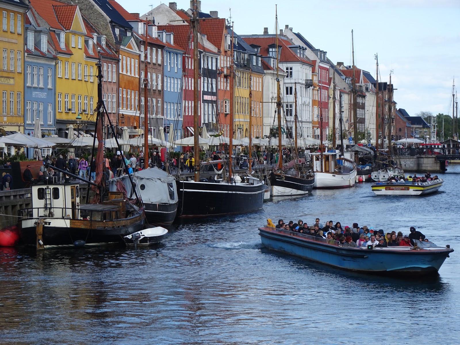
Copenhagen is a city of canals.  Hans Christian Andersen had a home on this street.

We had been here previously and had seen the attractions of the central city: the Little Mermaid, Tivoli Park, etc., but with sundown not until almost 10pm at this season, upon returning to the city in late afternoon, we did retrace a walking route through the city itself.  Copenhagen has extensive pedestrian-only street connections, plus many canals and regular streets.  You will always find a bike lane.


Sunday, May 26, 2019

Mallorca & Rome

The harbor at Palma de Mallorca contains a spectacular array of yachts of every description.  We can watch a continual parade of beautiful boats coming past our docked cruise ship.  We took a shuttle the 4 km. to the town center and then went on a taxi tour with another couple.  Palma itself is just another city (half the island population lives there); thus, we went to Valldemossa, a cute village toward the mountainous NW, for more relaxed surroundings.  Very enjoyable; would have been nice to stay there a few days.  But on a cruise, you only get a brief taste of the places visited.

Looking across a park at the cathedral in Valldemossa, Mallorca.  The village is easily walkable.

Fountain in a park along the waterfront in Palma, Mallorca.

Courtyard of the cathedral in Palma.

The yacht harbor and view of Palma from our cruise ship.

The alley our Rome "hotel"is located on.  Would you suspect a hotel is located here?  No sign; you must know the address which is printed in tiny numbers.


  Our room in central Rome was completely modern, beautiful, comfortable, spacious, custom breakfast, with an outdoor sitting area.... and less than $140 per night, with the complementary bottle of Chianti.  What a score!

A person could spend many days admiring the architecture and art of Vatican City.  This is the interior of St. Peter's Basilica.  (Yes, we weren't alone.)

Several blocks of semi-excavated Roman ruins.  A few structures are actively being rebuilt.

What is amazing is that there aren't hundreds of people in this photo, because they are there but cropped out.

We had been hesitating to visit Rome: just a big, congested, dilapidated, tourist-infested city. (all true)  But, the Roman and Catholic structures and art are truly amazing.  We took a taxi from the port (1 1/2 hours) to our "hotel" in the city center. Our room was not ready, so we dropped off our luggage and went out to explore for the next eight hours. First the nearby Pantheon; next lunch; then Castle Saint Angelo; and finally, the Vatican.  Walking back that evening, we stopped at a grocery store for meat, bread, and wine for dinner.  And our room (perhaps the wedding suite?) is outstanding. We slept with the doors open unto our third-floor patio.  Quiet.... in the center of the city.

May is too late to avoid the crowds, tens of thousands, that flock to Rome. To avoid the crowds, we were told to visit in January or February.  We visited the Colosseum today, but did not go inside.  The crowds were just too much.  We walked through entire city blocks of ancient ruins, also many blocks of interesting shops and restaurants.  Amazing that this all existed for thousands of years.  Just north of the Colosseum is a "bums' park" full of vagrants and trash and un-excavated ruins.  The new city is built among the foundations of the old city; you may find some ancient columns standing in a back alley.  The Rome airport, FCO, is excellent; it was selected as the best European airport for 2018.


Sunday, May 19, 2019

Cruise: England to the Med

A very small park near the waterfront in Southampton.  There is a small "old town" with parts of a city wall and old buildings, but nothing outstanding.

The ship is six months old and on its first European cruise.  I am not going to discuss the ship because cruising is a subject unto itself.  Our cabin looked out over the bow.

As you can see, a cloudy cool day in Bilbao, Spain.  We walked through the city and along the river getting our exercise, but otherwise found the area unremarkable.

After a pleasant overnight stay at a residential B&B in Southampton, we joined our cruise ship.  First stop was Bilbao, Spain.  The weather was overcast with periodic showers.  We weren't very impressed with the city, but perhaps the weather was a factor.  Lots of high density housing in a mountainous area inland from the mainly industrial harbor.  Most notable is the Guggenheim Art Museum.  Not being art fans, we spent more time in the Old Town neighborhood of narrow streets and small shops.

A plaza in the old town of A Coruna.  Perfect weather for a walk.

Tower of Hercules. a really old light house and very popular with tourists (but not too crowded).

Next stop was A Coruna which is located right on the coast in a large natural bay, popular for sailing.  One long sandy beach present, but still an amazing amount of high density housing.  The tourist info people have it all laid out: start at Old Town, then San Anton fort, a long walk along the Paseo Maritimo, the Tower of Hercules on a grassy peninsula, then back to Orzan Beach and the shopping areas. Good exercise on a beautiful day.

Looking out from our ship at the Lisbon hillside.  Because Lisbon sits on the open Atlantic coast, the weather here does not get excessively warm most of the time.

We have visited Lisbon previously; now we are here for the day (until 3:30pm).  The Lisbon city view consists of hillsides covered mainly with white buildings with red tile roofs.  It was suggested that we visit the Gulbenkian art museum while here; thus, we found the nearest Metro station and rode the underground train there.  Two parts to the exhibit:  older items including jewelry, furniture, paintings, sculpture, tapestries, etc. and then the modern art building.  Looking at modern art, I'd summarize that art is in the eye of the beholder.  The older items are amazing considering what they had to work with; the modern stuff didn't hold our attention as much.

Approaching Gibraltar.  The town to the left and "the rock" to the right; Spain is in the background.  The ship traffic here is heavy; this 15-mile wide channel connects the Mediterranean with the Atlantic.

Looking down from the "Rock" at Gibraltar city.  our cruise ship is visible and Spain is in the back ground.  Mark Zuckerberg's yacht is entering the harbor toward the left.  At this location, a Macaque monkey may come over to touch you, hoping for a treat.

This is the south gate of the city.  To the right (not seen) is a small, old, beautiful cemetery.  Beyond the gate is the crowded main street of Gibraltar, loaded with tourists from the two cruise ships in port.

Gibraltar was interesting; British, language in English, currency is the pound, but they drive on the right.  Spanish is also taught and used commonly.  The strait here is narrow enough that you can see Morocco (Africa) from this southern point in Europe. We joined with six other people to hire a van taxi for a tour.  It took us to the top of the "Rock"; great scenery and the Macaque monkeys. We even got in a long walk from the cable car back to our ship.

Wednesday, May 15, 2019

To Paris and Southampton

Touring the French countryside and visiting the various Great War memorials could make a very enjoyable vacation by itself.  Having a good GPS is essential; it serves as our tour guide.  The British approach was to bury their dead where they fell; thus, small British cemeteries are scattered throughout the region. (French forces manned the front further south.)  Other countries tended to gather their dead into larger consecrated sites.  Germany brought their dead back to the home country.  Commonly, a battlefield and museum are included with reflections on the period, home country and other events.  Studying WWI in this region is essentially a scavenger hunt of sites in the beautiful countryside.


The memorial at Belleau Woods, hallowed in the annals of the US Marine Corps.

The memorial is actually quite large with surrounding woods.

Our last day in France, we stopped at Chateau Thierry on our way back to Paris.  It is the location of a battlefield, cemetery, and memorial famous to the US Marines of Belleau Woods.  Unfortunately, we are short on time.  By the time we located the memorial, we needed to move on to Paris.  Tonight we sleep in Southampton, England.

Sunday, May 12, 2019

Amiens, France- World War I Remembered

From our B&B on a farm near Bayeaux, we have driven to the village of Croissy-sur-celle almost 300 kilometers to the northeast.  Everywhere we look, the fields and forests are lush with vegetation.  Our B&B here is near the center of the village.  Surrounded by a high wall with a locking gate, there is a large courtyard and a stream flowing across the back of the property.  We slept with the window open, and it was perfectly quiet at night!  These small ancient villages are everywhere, and we are wondering if they are maintaining their vitality, or are the young people moving to the cities?

Looking out our guest room window at the courtyard of our B&B.  Our little VW T-Roc is parked in the shade.  Our hostess speaks very little English, but we get by, and she serves wonderful breakfasts.

Longueval.  The memorial to South African and New Zealand troops who fought in the surrounding Delville woods.  We are looking from a distance; the site includes a museum.

Beaumont-Hamel.  Battleground and memorial to Newfoundland soldiers trapped in these trenches by fierce German gunfire.  Remember, what we are seeing is more than 100 years old.  Nearby is a massive monument at Thiepval commemorating more than 72,000 missing Commonwealth soldiers.

Lochnagar Crater was caused by underground explosives which were set off to completely eliminate the enemy front lines.  A hole about 50 yards in diameter.  Most notable are the placards detailing certain people and events.  PTSD was not recognized at this time.  This war was so wasteful of human life that 27,000 French troops mutinied, and the leaders of the mutiny were shot.  Enlarge and read the inscription.

After a day of visiting WWI monuments, it makes WWII look like a cake walk.  Imagine 60,000 casualties in ONE day on one battlefield.  Imagine a unit of 3,200 sent to clear a forest and only 143 walks out at the end of the week-long operation.  The British alone suffer a million dead, not counting the French, Germans, Belgian, US, and others.  More soldiers lost in this war than WWII.  The countryside here in the eastern Somme is dotted with military cemeteries.  Not as crowded with visitors as Normandy.... these men are only faded memories to their descendants.  At Thiepval is a monument to the more than 72,000 missing Commonwealth soldiers from this war.  Think about that.... doesn't include French, German, or others; these are dead whose bodies were never found; bodies ground to pulp in the artillery barrages of "No man's land" and trench warfare.

Villers-Bretonneux.  Site of the Monash Center, an outstanding monument/museum to the Australian contribution to the war.  General Monash is celebrated because he carefully planned and coordinated all aspects of the attack with the result that the battle was won in 93 minutes with minimum loss of life.  About 1000 US troops were included in the attack.  The actual battlefield is located at Le Hamel, nearby.

We had a great day; our first stop was the American military cemetery at Bony.  There we met the superintendent and his wife, Craig & Lorna, who invited us into their home and laid out a list of places to visit.  They even told us where to find lunch, a restaurant run by a Brit expat frequented by British visitors.  Had a bit of an "adventure" coming home (Sunday evening) when the gas tank read empty.  The first gas station we stopped at was closed; the second was diesel only; and the third was automated but wouldn't accept our credit cards.... until the third try!


We stopped at the village of Frise to take a walk along the canal banks and encountered this party of boaters making their way through the locks and down the river on a beautiful day.

The monument at Vimy ridge.  A large park, woods, trench system, tunnels, and a museum are all located at this site.  We were given a guided tour of a section of the remaining tunnels.

Posted in the museum at Vimy ridge.  The author, a Canadian, was later killed in battle.

Our farthest drive was to Vimy Ridge, just north of Arras.  The battlefield there is well preserved.  We were able to walk in a section of the tunnels built there over 100 years ago which still exist.  There are still areas with signs warning of unexploded ordnance.  Farmers in this part of France still find projectiles and other items in their fields every year.   We visited the American monument at Belleau Wood on our last day here.  Ask any US Marine; this is an important battlefield in the history of the Corps.

Monument at Belleau Woods.  By the time we located this monument, we had less than an hour to explore before heading for Paris and our flight to England.


We have lightly covered the section of the battlefields and monuments of WWI between Arras and Chateau Thierry in the past few days.  We have only sampled about 100 miles of the 500 mile long Western Front of WWI, but this includes the areas where most American troops were deployed.  The area is beautiful, quiet, rural landscape with many prosperous farms and green leafy forests.  Because this area is not so touristy, nice accommodations are not as numerous.  The events that happened here may be considered more world-shaping than WWII, but the people who remember these events are all gone now.

Friday, May 10, 2019

Normandy, France

Leaving Paris in our rental car was one intersection at a time, including security road blocks, road repairs, and noon-time traffic. Then it was open road except for toll booths; veer to the right to use the booths that accept credit cards.  Our destination is a farmhouse outside a village south of Bayeaux.  Past a one-lane bridge, the farmhouse is 500+ years old; stone walls two feet thick, doorways less than six feet tall, ancient & massive beamed ceilings, but all restored using modern and beautiful finishes.  The farmhouse had been vacant since the French Revolution (look that date up) prior to this renovation. An engaging and educated little French lady serves a wonderful breakfast with homemade croissants & breads, goat cheese, fruit, and eggs.  The pasture holds three horses and a donkey. Her dog, Charlie, came out to greet us while the cat hid outside.  In any organized tour, you could never enjoy such a personalized experience; she only has two rooms to rent.

Our B&B, a ancient farmhouse brought up to modern standards and located on 34 acres.

Our bedroom.  Absolutely gorgeous; renovated after 200 years of neglect.

The cathedral at Bayeau, France.  Although Bayeau is located directly inland from the D-Day beaches, it received only minor damage in the conflict.

Bayeau is a scenic town, well-located to explore the Normandy area, and small enough that you can explore its streets on foot.

Dawn's father crossed this beach at about noon on D-Day, 75 years ago as the driver of a half-track vehicle.  He participated in the entire march across Europe; major battles, mass graves, opening of concentration camps, until meeting up with the Russians.  It was 40+ years before he spoke about it and then only small snippets of what he experienced.

The cliffs of Pointe du Hoc where American Rangers climbed up ropes, under murderous German fire, to disable the large artillery located there.

Breakfast was shared with a couple from Germany.  We had a interesting discussion including WWII,  the re-unification of Germany, and modern day Europe. Experiences like this will never be forgotten.  Off to visit the D-Day beaches; tomorrow is the 75th anniversary of VE (victory in Europe) day.  To see Omaha Beach, look for signs for the American Military Cemetery.  The cemetery is located directly adjacent to the beach.  Ocean waves were lapping at the foot of cliffs in what is now a peaceful view of the ocean and farmers' fields.  Beautiful, well done, and well maintained; if you even pause to reflect, it will bring tears to your eyes.

On D-Day, this wide-open beach offered no protection for the American amphibious advance resulting in massive casualties.

I brought back no pictures of the American Cemetery.  It had the feel of a holy place, a place of personal reflection and appreciation; not a place for tourist "trophy" photographs.  More than 9,300 graves are located here; each one representing a young life cut short.

Today you can find land sailers enjoying wide Omaha beach.  This is not a new sport; it has been enjoyed for over 100 years.

We stopped at an excellent museum in Bayeaux which showed archival coverage of the 1944 offensive; I was left with an increased appreciation of the horrendous violence of this conflict.  Human bodies were like moths before a flame; snuffed out by the thousands.  A better museum is located at Utah Beach.  Along this Normandy coast, various exhibits detail the invasion in a complete and balanced manner.  Many of the visitors are French, but the Germans come here also.  Visiting Pointe du Hoc completed our visit.

Looking down the barrel of a German defensive artillery piece overlooking the beaches.

Everyone said, "You must visit Mont St. Michel." and so we did.  It is beautiful; it is unique; it is a tourist trap.  If I had it to do over, I would not have gone there.  A long drive to be caught up in an endless crowd where every scene was dominated by surrounding bodies.

A virtual island at high tide connected to the mainland by a causeway.

List of Travel Entries, November 2026

  Entry titles are listed in order from oldest to newest (top to bottom) in this index; however, the actual blog entries are posted from old...